NISAR – India-US Joint Mission Launches Earth’s Most Powerful Observation Satellite
Introduction (Why in News)
On July 29, 2025, the Indian Space Research Organisation (ISRO) and the United States’ NASA launched NISAR (NASA-ISRO Synthetic Aperture Radar), the world’s most powerful Earth observation satellite. After a decade-long collaboration and a budget of over $1.5 billion, NISAR represents an advanced step in space-based Earth monitoring, making headlines across the globe. Equipped with dual-band Synthetic Aperture Radar (SAR) systems operating in L-band and S-band, NISAR will produce high-resolution images capable of penetrating vegetation, clouds, and even some ground surfaces to map Earth changes in real-time.
This launch is significant not just for scientific research but also for geopolitical, environmental, and technological developments, all highly relevant themes for CLAT 2026 Current Affairs. Understanding NISAR aligns with the aspirants’ broader awareness of national and international collaborations in science and technology, one of the key topics under CLAT General Knowledge and Current Affairs section.
Point-Wise Summary of the Article
- What is NISAR?
- NISAR stands for NASA-ISRO Synthetic Aperture Radar.
- It is a joint Earth-observing satellite developed by ISRO and NASA.
- It is considered the most advanced Earth observation satellite to date.
- Purpose of NISAR
- To study changes in Earth’s surface including landslides, earthquakes, glacial movements, and agricultural cycles.
- Will assist in disaster management, natural resource monitoring, and climate change research.
- SAR Technology (Synthetic Aperture Radar)
- SARs are radar systems that emit microwave signals and receive echoes to form images.
- They can capture data day or night and in all weather conditions.
- SARs penetrate clouds, vegetation, and in some bands, even soil — making them ideal for environmental monitoring.
- Dual-band SAR System
- NISAR features two radar systems:
- L-band SAR (provided by NASA): Deeper penetration, captures larger-scale movements, useful for agriculture and forests.
- S-band SAR (developed by ISRO): Offers sharper, shallow imaging, useful for infrastructure and urban mapping.
- These bands help detect both surface-level and deep-earth movements simultaneously.
- NISAR features two radar systems:
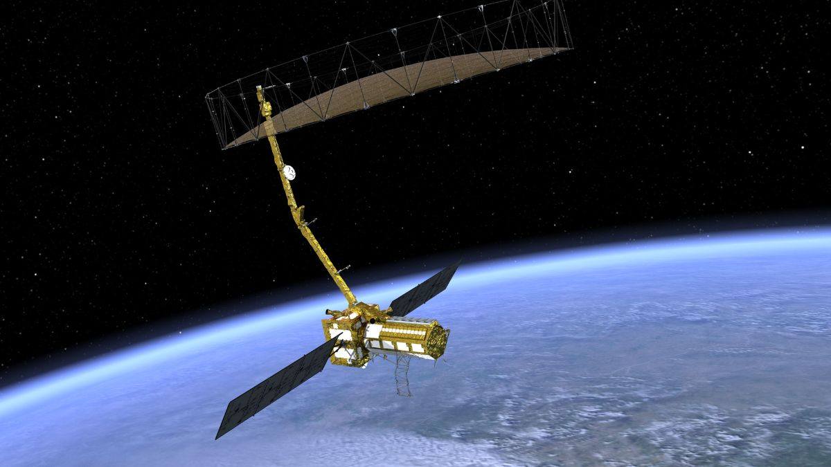
- NISAR’s Technical Specs
- Radar Antenna Reflector: 12-meter diameter; captures high-resolution data.
- 3L-band SAR: Can map below the ground level using low-frequency microwaves.
- 4S-band SAR: High resolution, but cannot penetrate deep — captures crop fields and urban landscapes well.
- Solar Arrays: Provide electric power to onboard systems.
- Scientific and Strategic Applications
- Observes ice sheet collapses, soil moisture, crop mapping, deforestation, earthquake displacements.
- Helps build early warning systems for disasters.
- Valuable in studying carbon stock, glacial melting, and coastal erosion.
- ISRO-NASA Collaboration
- NASA provided the L-band radar, spacecraft bus, launch integration, and part of the ground system.
- ISRO developed the S-band radar, the GSLV launch vehicle, and part of the mission operations system.
- Collaboration since 2007, with final cost-sharing reflecting $1.6 billion from NASA and ₹900 crore from ISRO.
- Mission Operations
- NISAR will operate in a low Earth orbit (~747 km).
- Expected to function for at least 3 years.
- Data will be shared with both India and the US, and made available globally to researchers and governments.
- Technological Challenges Overcome
- Integrating two different radar systems required overcoming engineering complexity.
- Aligning signal processing and resolution outputs for both SARs was a major feat.
- Global Impact
- NISAR will provide free and open-source data, enabling global research in agriculture, water resources, disaster preparedness, and more.
- Seen as a model for international scientific collaboration in space technology.
Explanation of Peculiar Terms for CLAT Aspirants
Term | Explanation |
Synthetic Aperture Radar (SAR) | A type of radar used to create detailed 2D or 3D images of landscapes by bouncing microwave signals off the Earth’s surface. |
L-band SAR | Long wavelength radar (~24 cm); penetrates vegetation, ideal for environmental monitoring. |
S-band SAR | Shorter wavelength (~12 cm); high resolution, but less penetration. Suitable for urban observation. |
GSLV (Geosynchronous Satellite Launch Vehicle) | India’s heavy-lift launch vehicle used for placing satellites in high Earth orbits. |
Microwaves | A form of electromagnetic radiation with wavelengths used in radar systems. |
Carbon stock estimation | Process of calculating the amount of carbon stored in vegetation and soil — vital for climate science. |
Disaster early warning systems | Tech-driven forecasting systems that warn about natural disasters like earthquakes, landslides, or cyclones. |
Open-source data | Freely available data without restrictions for global researchers and governments. |
CLAT 2026 Relevance and Legal-Academic Insights
- International Cooperation in Science and Technology
- NISAR is a leading example of India-US cooperation, relevant under International Relations, and Science, Technology & Innovation Policy for CLAT aspirants.
- Environmental Law and Policy
- NISAR will monitor natural resources, deforestation, and glacier retreat — all key to understanding India’s climate commitments under the Paris Agreement and UNFCCC.
- Disaster Management
- NISAR’s use in disaster early warning systems aligns with India’s Disaster Management Act, 2005, which emphasizes technology for mitigation and preparedness.
- Constitutional Provisions
- Relevant under Article 51A(g) – Fundamental duty to protect the environment.
- Also links to Article 73 and 253, enabling Parliament to legislate on international treaties and space cooperation.
Strategic Importance for India
- Strengthens India’s space diplomacy and image as a global space power.
- Demonstrates ISRO’s capabilities in building complex missions with international agencies.
- Assists state governments in precision agriculture, forest governance, and disaster resilience planning.
Conclusion
NISAR’s successful launch signals a new era in Earth observation technology, strengthening India’s global scientific standing while equipping it with critical data to tackle climate change, agriculture, and natural disasters. For CLAT 2026 aspirants, this represents a case study in policy, law, international collaboration, and environment, all rolled into one.
As India leads in space innovation through ISRO, integrating global cooperation and indigenous capacity, students preparing for national-level legal and civil services exams must stay updated with such landmark missions. NISAR is not just a technological marvel — it’s a testament to the power of data, diplomacy, and development.
This Blog is Powered by CLAT Gurukul — India’s Leading Law Entrance Prep Platform
At CLAT Gurukul, we believe in empowering future legal minds with the right blend of knowledge, strategy, and mentorship. This blog is a reflection of our commitment to quality content that not only helps aspirants stay updated but also sharpens their conceptual clarity.
Why CLAT Gurukul?
- Personalized Mentorship by Top Legal Educators
- Comprehensive Study Materials & Legal Updates
- Daily Practice Sets, Mocks & Performance Tracking
- Result-Oriented Strategy for CLAT, AILET, and CUET
Whether you’re reading this article to deepen your understanding or to stay ahead in your exam prep — you’re already one step closer with CLAT Gurukul by your side.
Join thousands of successful aspirants who trusted CLAT Gurukul and cracked India’s top law entrance exams.
Visit https://www.youtube.com/@CLATGurukul/shorts to learn more or speak to our experts now!
Note from CLAT Gurukul
At CLAT Gurukul, we are committed to providing free CLAT study material, including CLAT current affairs, legal reasoning practice sets, general knowledge updates, logical reasoning questions, English comprehension exercises, and more — all curated by top mentors.
Our blog section is regularly updated with high-quality CLAT content tailored to match the evolving pattern of the CLAT UG exam. Whether you’re looking for CLAT 2026 current affairs, CLAT legal reasoning passages, or mock practice sets, we have you covered.
We believe in open-access learning and will continue to publish free CLAT preparation resources to help serious aspirants succeed.
Explore more free content under categories like:
Best online coaching for CLAT, CLAT current affairs, CLAT GK updates, CLAT legal updates, CLAT logical reasoning, and CLAT English preparation.
For structured learning, daily mocks, and expert mentorship, visit https://www.youtube.com/@CLATGurukul/shorts — the Best CLAT Coaching in Patna and India’s most trusted platform for CLAT online coaching.